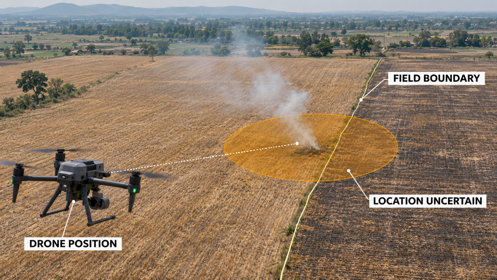
A drone captures smoke rising near an agricultural field.
The image has coordinates. The video has a timestamp. A map shows the observation close to a land parcel.
Should an authority issue a notice?
Not yet.
The image may be valuable evidence that something needs investigation. But a location tag alone does not establish exactly where the incident occurred, what caused it, who was responsible or whether the evidence meets the requirements for enforcement.
That distinction is becoming more important as drones, satellites, cameras and AI systems move from monitoring physical conditions to supporting decisions that affect people, property and businesses.
From detection to consequence
On 3 November, the Agriculture and Farmers’ Welfare Department in Panchkula reportedly began using drone surveillance to monitor possible crop-residue burning. The department said suspected incidents would be documented with geotagged photographs and video, along with location and time.
The application is understandable. Drones can help teams cover more ground and document conditions that may be difficult to inspect quickly from the road.
But when an observation may lead to a notice, financial penalty or other consequence, the question changes.
A monitoring team may ask:
“Did the drone see something that requires attention?”
An enforcement authority must ask:
“What can we reliably establish, and is it enough for this particular action?”
Those questions require different levels of evidence.
What does the geotag actually locate?
Consider an illustrative example.
A drone records smoke near the boundary between two fields. The image file contains coordinates from the drone’s positioning system.
Those coordinates may identify the camera or aircraft position at capture. They do not necessarily identify the precise ground location where the fire began.
To estimate the location of the observed feature, the team may also need to consider:
- Camera direction and angle.
- Aircraft altitude and positioning uncertainty.
- Terrain and viewing geometry.
- How accurately the image can be aligned with the ground.
- Whether smoke has drifted away from its source.
- The quality and currency of the land-parcel boundary.
A pin on a map can look precise even when the underlying position has a meaningful uncertainty.
If that uncertainty overlaps two parcels, selecting one parcel may be premature. A closer observation, a different camera angle or a field visit may be needed.
Even a correctly located fire does not, by itself, establish who started it or who is legally responsible. Ownership, cultivation, occupancy and responsibility are separate questions that may require separate records and review.
An image can support one claim and leave another unresolved
Evidence quality depends on the claim being made.
The same drone video might support the statement:
Smoke was visible in this area at approximately this time.
It may also support a narrower assessment that active burning was visible within a particular area.
But it may not establish:
- What material was burning.
- Exactly where the fire started.
- Whether it crossed a boundary.
- Whether a particular person caused it.
- Whether the applicable conditions for a violation were met.
This distinction matters because digital systems often turn observations into labels too quickly.
A workflow may begin with “possible fire detected”, become “field identified”, and appear on a dashboard as “violation confirmed.”
Each transition adds a claim. Each claim needs its own support.
An AI model can help prioritize images for review. Its confidence score may indicate how strongly the model associates an image with a pattern it was trained to recognize. It does not, on its own, establish the location, cause, responsible party or legal significance of the event.
Preserve the observation before interpreting it
If an image may support a consequential decision, the original observation needs to remain available alongside any processed versions.
That includes the earliest available original file, relevant metadata, capture information and a record of how the file was transferred and handled. Cropped images, annotated screenshots, maps and AI-generated detections can be useful working material, but they should remain distinguishable from the source.
A cryptographic hash can help teams check whether a file has changed since the hash was calculated. NIST’s digital-evidence preservation guidance also stresses documenting the source and handling of digital material.
There is a practical limit: a matching hash does not prove that the camera’s location was accurate, that the clock was correct, or that the image shows what a reviewer believes it shows. It helps with file integrity from the point of hashing; it does not settle the underlying facts.
Likewise, a well-maintained chain of custody helps explain who handled the material and what happened to it. It does not replace an assessment of relevance, accuracy or the applicable legal process.
A practical evidence workflow
For organizations designing geospatial monitoring systems, I suggest treating evidence as a sequence of decisions rather than a single file.
1. Detect
Record what the sensor or reviewer observed.
For example: “Possible smoke detected in this image.”
Keep the observation separate from assumptions about cause or responsibility.
2. Locate
Estimate where the observed feature is on the ground, using the available imagery, positioning information and appropriate spatial methods.
Record the uncertainty and the limitations of the parcel or asset data used for comparison.
3. Review and corroborate
Ask whether the available material supports the proposed claim.
A reviewer may need another image, a field inspection, an independent record or a clearer view. Conflicting evidence and reasonable alternative explanations should remain visible in the case record.
4. Assess against the decision
The evidence needed to dispatch an inspector may be different from the evidence needed to issue a notice or impose a sanction.
The responsible authority should determine what additional procedural and legal requirements apply, including opportunities for the affected party to respond or challenge the finding.
5. Record the outcome
Preserve the decision, who made it, the evidence they considered and any subsequent correction, response or appeal.
A useful status sequence could be:
Detected → Under review → Verified for a defined claim → Accepted for a specified decision
There should also be routes for uncertain, rejected, corrected or disputed findings. Progress is not always linear, and a verified observation is not automatically an accepted enforcement case.
The business case for evidence discipline
This is not only a public-sector issue.
A construction owner may use a drone to identify work outside an approved boundary. A utility may review imagery for suspected encroachment near a transmission corridor. An environmental team may monitor activity close to a protected area.
In each case, an image can help direct attention. A consequential decision requires the organization to understand what the image can and cannot establish.
Poor evidence handling can create avoidable field visits, delays, disputes and loss of trust. Equally, demanding a full investigation for every low-risk alert can overwhelm teams.
The practical answer is to match the effort to the decision:
- Triage: Is there enough information to inspect?
- Verification: Is there enough information to support a specific finding?
- Action: Has the authorized decision-maker assessed the evidence and applicable procedure?
This allows teams to move quickly on early warnings while applying more scrutiny as the consequences increase.
A useful role for geospatial platforms
A map can show where an observation may be relevant. A stronger evidence workflow can also show:
- The original image and related files.
- The location estimate and its uncertainty.
- The parcel or asset dataset used, including its date.
- The specific claim under review.
- Supporting and conflicting observations.
- Processing and review history.
- The decision, its owner and its current status.
This creates continuity from observation to decision. It also makes it easier to revisit a conclusion when a boundary is corrected, new evidence arrives or an affected party disputes the finding.
Geospatial technology is becoming better at helping us see. Its value in enforcement will depend just as much on whether we preserve the context needed to interpret what was seen.
A geotagged image may be the beginning of a case. The quality of the decisions that follow depends on the evidence built around it.