Imagine a highway bridge crossing a major Indian river.
Every year, engineers inspect its deck, bearings, expansion joints and visible concrete piers. Drones capture high-resolution imagery. LiDAR generates detailed 3D point clouds. A digital twin presents the structure in remarkable detail.
The bridge appears healthy.
But beneath the water, something is changing.
Successive monsoon floods have gradually eroded the riverbed around one of its foundation piles. The sediment that once provided lateral support is disappearing. The foundation is becoming increasingly exposed.
The drone cannot see it. The conventional topographic LiDAR cannot measure it. And the digital twin may not even represent it.
This is not simply a data collection problem.
It is a discontinuity between the physical infrastructure we can observe and the infrastructure we need to understand.
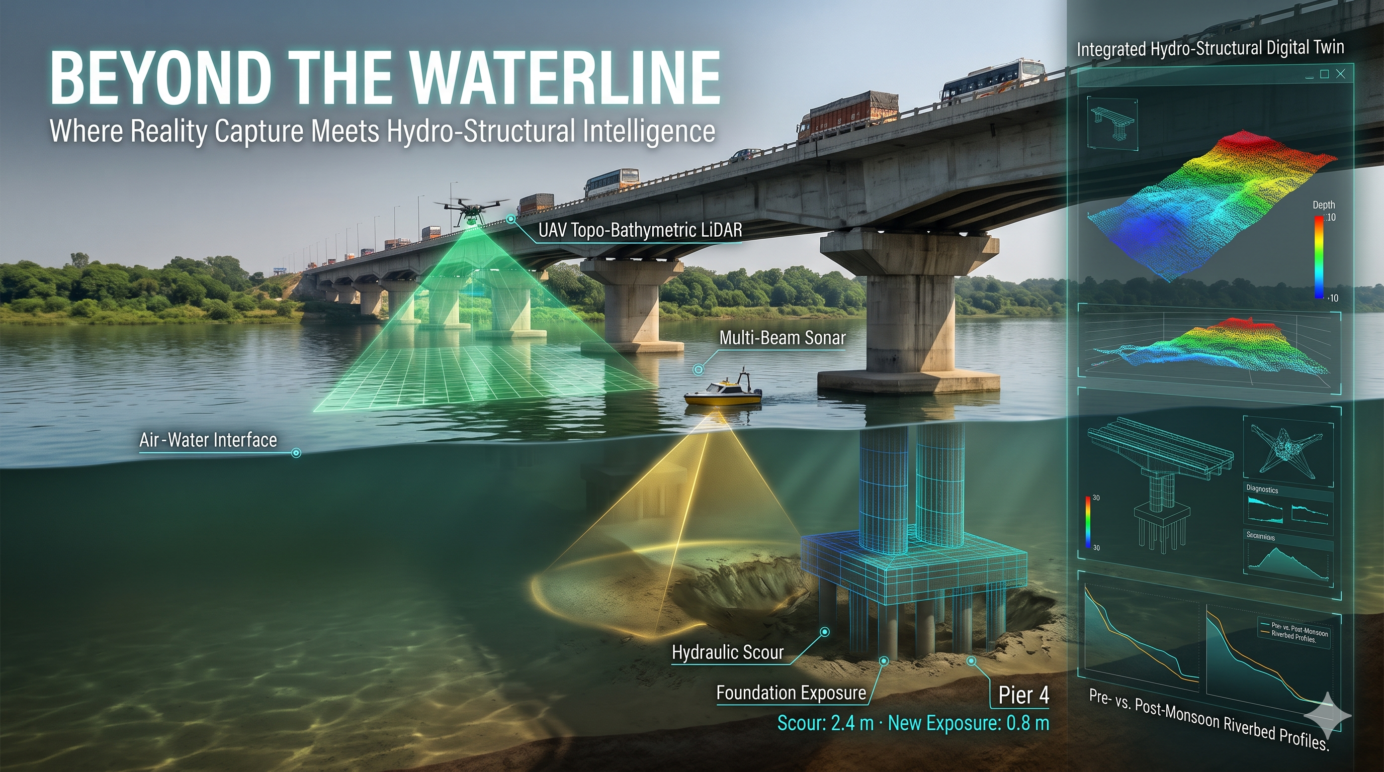
This week, GeoThinking explores how fusing UAV-based Topo-Bathymetric LiDAR with USV-based Multi-Beam Sonar could help close this gap and create a new category of infrastructure intelligence: Hydro-Structural Digital Twins.
1. The Problem: Infrastructure Does Not End at the Waterline
Bridges, dams, barrages, spillways and port jetties operate across two fundamentally different physical environments.
Above water, we have relatively mature reality capture technologies. Drones, terrestrial laser scanners and mobile mapping systems can document structural geometry and visible deterioration.
Below water, the situation changes.
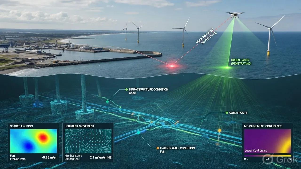
Conventional topographic LiDAR operates primarily using near-infrared wavelengths that are strongly absorbed by water. It cannot reliably map submerged foundations or riverbeds.
Meanwhile, traditional hydrographic surveys often operate as separate engineering exercises, producing bathymetric maps that may never become part of the structural asset model.
The result is fragmented infrastructure intelligence:
- Structural engineers understand the bridge geometry.
- Hydrographic teams understand the riverbed.
- BIM managers maintain the digital asset model.
- Maintenance teams receive inspection reports.
But who understands the relationship between the changing riverbed and the structural foundation?
A bridge can remain geometrically unchanged above water while its foundation conditions deteriorate beneath it.
That relationship matters because hydraulic scour, the erosion of sediment around foundations, is a significant threat to bridge stability.
2. The Technology Fusion: One Environment, Three Sensing Modalities
Amphibious reality capture combines complementary optical and acoustic technologies rather than expecting a single sensor to see everything.
Topographic UAV LiDAR
A drone equipped with near-infrared LiDAR captures the bridge superstructure, exposed piers, riverbanks and surrounding terrain.
It establishes the above-water spatial context.
Topo-Bathymetric UAV LiDAR
Topo-bathymetric systems use green laser wavelengths, typically around 532 nm, to penetrate sufficiently clear water. Combined with near-infrared sensing, they can capture the land-water transition and shallow submerged terrain.
This is particularly valuable around riverbanks, shoals and areas that vessels may struggle to access.
However, optical penetration depends heavily on water clarity.
USV Multi-Beam Echo Sounder (MBES)
An Unmanned Surface Vessel carries a sonar system that transmits multiple acoustic beams across the water column, mapping riverbeds and submerged structures.
Unlike optical LiDAR, sonar is not dependent on water transparency. It can investigate deeper channels, scour depressions and exposed foundations in turbid water.
Together, these systems can produce a connected representation of the infrastructure environment:
Bridge deck → Structural piers → Water surface → Submerged foundations → Riverbed geometry
The objective is not merely a larger point cloud. It is a spatially connected engineering representation.
3. The Difficult Part Is Not Capturing Data. It Is Making the Data Agree.
Combining aerial LiDAR and underwater sonar is more complex than importing two point clouds into the same software.
Each sensor observes reality through different physical principles.
Green laser pulses bend when passing from air into water. Without refraction correction, submerged geometry can be displaced.
Sonar calculates distance using acoustic travel time. Changes in water temperature, salinity and other water-column conditions affect sound velocity and therefore depth measurements.
Positioning introduces another challenge. GNSS reception can deteriorate beneath bridge decks, while water levels may change between aerial and underwater surveys.
A reliable fusion workflow therefore requires:
- Optical refraction correction using the observed water surface.
- Acoustic sound velocity measurement and correction.
- Common horizontal coordinates and vertical datums.
- Calibrated sensor positioning, orientation and timestamps.
- Independent checks of overlapping survey surfaces.
Imagine a digital twin reporting that the riverbed has eroded by 20 centimeters.
Is that actual erosion? A vertical datum mismatch? A positioning error? Or uncertainty in the water-column correction?
A seamless-looking model is not necessarily an accurate engineering model.
The system must preserve how each surface was measured, where the uncertainty lies and whether the observations are sufficiently aligned for comparison.
4. From Hydrographic Point Clouds to Hydro-Structural Digital Twins
The real value emerges when the captured environment is connected to structural BIM and spatiotemporal GIS.
Consider a bridge foundation represented using IFC-based BIM elements.
The foundation model contains the designed pile geometry, pile cap elevation and embedment information. The bathymetric survey provides the current riverbed elevation around that foundation.
Registering these datasets allows engineers to investigate a different class of questions:
How much foundation is exposed? How has the riverbed changed since the previous monsoon? Which pier is experiencing the greatest erosion? Does the observed change require a detailed structural assessment?
Time-indexed GIS surfaces extend this capability.
Instead of replacing last year's bathymetric model with this year's survey, the digital twin preserves successive survey epochs. Elevation differencing can reveal erosion, deposition and changes in scour geometry.
Hydrodynamic simulations can then use the updated terrain and riverbed geometry to investigate potential flow behavior during future flood conditions.
But an important distinction remains.
Measured scour is an observation. Future scour is a prediction. Structural safety is an engineering determination.
A responsible digital twin must preserve those boundaries.
5. The GeoThinking Scenario: A Bridge After the Monsoon
Consider an illustrative post-monsoon inspection of a highway bridge.
Observe: A UAV captures the bridge and surrounding riverbanks. A compact USV maps the submerged riverbed and accessible foundation surfaces.
Understand: The two datasets are corrected, georeferenced and registered against the bridge's BIM model.
Prioritize: Comparison with the pre-monsoon baseline identifies a 2.4-metre scour depression near Pier 4 and approximately 0.8 meters of newly exposed foundation.
Decide: Structural engineers assess the remaining embedment, foundation design, soil conditions and hydraulic loading to determine whether intervention is required.
Assign: Following engineering approval, a maintenance work order specifies the affected location, remediation design and estimated material quantities.
Act: Contractors implement an approved scour protection measure, such as engineered riprap.
Verify: A follow-up USV survey checks the accessible repaired geometry against the design and establishes an updated monitoring baseline.
The digital twin connects these observations, decisions and interventions across time.
It is no longer simply a representation of the bridge.
It becomes part of the bridge's inspection, maintenance and verification workflow.
6. Where Are We Today?
The individual technologies are already operational.
UAV LiDAR, bathymetric LiDAR and compact USV multibeam surveys are available. Their integration with structural BIM, automated change detection and recurring maintenance workflows represents the more challenging stage of deployment.
Several practical boundaries remain.
During Indian monsoon conditions, suspended sediment may severely limit optical bathymetry. Acoustic sensing becomes particularly valuable, but high currents, debris, acoustic shadows and restricted manoeuvrability can still prevent complete coverage.
GNSS-denied environments beneath bridge decks may require alternative positioning methods.
And sonar cannot see through sediment to measure deeply buried piles directly. Their geometry must come from credible design records, as-built information or additional investigation.
This means an amphibious digital twin should explicitly distinguish measured geometry, inferred geometry and areas that remain unobserved.
7. The Strategic Opportunity for India
India has an opportunity to rethink how it procures the monitoring of river-crossing and hydraulic infrastructure.
Instead of commissioning separate drone mapping, hydrographic surveys and structural documentation exercises, asset owners could adopt an Integrated Amphibious Digital Twin Service.
A recurring service could combine pre- and post-monsoon surveys, foundation-specific change detection, BIM-linked inspection records, GIS-based sediment analysis and verification of maintenance interventions.
The same architecture could support:
- Highway and railway bridges exposed to hydraulic scour.
- Dams and reservoirs experiencing sediment accumulation.
- Barrages and spillways requiring bed-condition monitoring.
- Ports and jetties managing underwater structural assets.
The commercial value is not measured by the number of drone flights or sonar points delivered.
It comes from earlier identification of concerning changes, better-targeted inspections, improved maintenance planning and a defensible record of infrastructure condition.
This is where geospatial technology moves from survey delivery towards recurring infrastructure intelligence.
The GeoThinking Perspective
For years, infrastructure digital twins have focused on making physical assets visible.
But visibility alone is not enough.
A bridge is not just its concrete and steel. It is a structural system interacting with water, sediment, foundations and changing environmental forces.
A digital twin that captures the bridge but ignores the changing riverbed represents only part of that system.
The next step is not to replace aerial surveys with underwater surveys. It is to connect both into a continuous spatial and temporal understanding of infrastructure.
When reality capture crosses the waterline, digital twins can begin to connect structural condition with the environmental processes that influence it.
That is the promise of hydro-structural intelligence.
And perhaps the most important question is no longer:
How accurately can we model a bridge?
It is:
How well can we understand the changing conditions that allow the bridge to remain standing?
Let's GeoThink Together
If you manage bridges, dams, barrages or port infrastructure, how are you currently connecting above-water inspections with underwater foundation and riverbed monitoring?
At BSMA Enterprises, we are bringing together advanced reality capture, AI-assisted bridge inspection, structural health monitoring, engineering-led condition assessment and BIM-GIS Digital Twins through our technology and engineering collaborations.
Our approach connects drone-based 3D inspection, defect identification, bridge health indexing and sensor-based structural monitoring with geospatial intelligence, while exploring the integration of hydrographic surveys to extend infrastructure monitoring below the waterline.
From periodic inspections to continuous monitoring, condition assessment, maintenance prioritization and post-intervention verification, our objective is to help infrastructure owners move towards a connected, evidence-driven asset management framework.
If you are an infrastructure owner, highway or railway authority, engineering consultant, or asset management organization looking to modernize your bridge inspection and monitoring workflows, let's connect and explore how these capabilities can be integrated for your infrastructure.